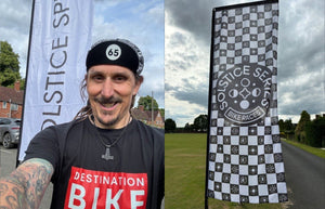
Skip to content
Solstice Sprint

Solstice Sprint

Guided by the pillars of Adventure, Competition, and Community, participants will embark on a 1000KM journey through a kaleidoscope of landscapes in the South West of England and across Wales. Before the race begins, unite with fellow riders at the pre-race celebration dinner, setting the stage for an unforgettable experience.

The long days and mild weather create the perfect conditions for riders to prove themselves in one of the earliest races of the calendar, setting the tone for what is to come later in the season.

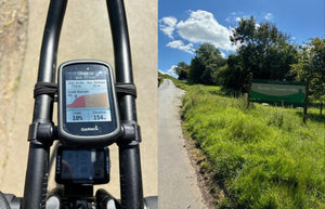
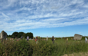
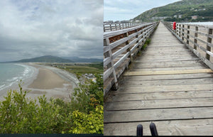
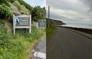
The 2024 route has been described as a medley of brutal climbs and beautiful vistas, visiting areas including; the Cotswolds, North Wessex Downs, Wye Valley, Eryri National Park, The Great Orme and the Shropshire Hills.

Words and pictures by Rupert Robinson

Older Post
Newer Post

The off from Warwick

I headed over to Warwick on Wednesday afternoon to register before the 10am start the following day. Registration was seamless, where I got my cap and tracker and presented the mandatory items we needed to carry. This was a high viz strap/waistcoat, front and rear lights, a mobile phone, and an emergency blanket. This was topped off with a nice selection of pasta and salad with a few familiar faces and new ones. I chatted to Stefan Powell as he was about to embark on his first ultra. We hit it off and exchanged stories of how we arrived at this point together.

The Kit

Once I had done this, I returned to my accommodation, did the obligatory checklist pictures, and settled in for the night. I was hoping to be asleep by 10pm with a very reasonable rise around 07:30 the following morning. I planned to be out and on the way by 08:30 which gave me enough time to drive to a pre-paid parking place close to the start and then ride round to join the other participants.

Starting and finishing in Warwick Sports Ground, this race covered 1000 km and 10 checkpoints.

Off and climbing

Heading south from Warwick, the first checkpoint was the Burton Dassett Hills, which came pretty quickly and around the 32km mark as we made our way to Banbury. There was still plenty of riders at this point and this was a lovely climb.

Continuing south via Hungerford and Inkpen came the first real test of the day and checkpoint 2 up the climb of Coomb Gibbet. Luckily for me I had done this climb as part of the recci a few months back but with a loaded bike, it was by no means any easier knowing what was coming. Sitting in the Official 100 climbs at no 25, the main drag is just under 1km at an average of 9.2%. Normally I’m not too bad at this but the heat was kicking in right now. CP2 was at 157km. a real bonus to this race was the non-admin CP’s. Other races I've done require a brevet card and a question to be answered so this adds another level of complexity when you are tired, but we didn’t have to do that on this race.  The descent was very much welcomed by the time I crested the top.

Summer Solstice

As the day heated up, we looped back up towards Hungerford and then west towards Devizes. I’d already started suffering from cramps in both quads so stopped here, and grabbed a coffee, some drinks and a salty portion of chips. A couple of riders stopped here also, including Matthew Vickers, with whom I would be to-ing and fro-ing with for most of the day. I’d met Matt previously at All Points North, another ultra race,  and he was riding strong with minimal luggage. We chatted for a bit and then headed off knowing we’d more than likely see each other again.

At around 230km, and 9 hours in I rode through the World Heritage Site at Avebury. I had already forgotten we were on the Solstice and the place was heaving! Of course, it would be. Avebury Henge dates from around 4,600 years ago. The bank and ditch are almost a mile in circumference, and the ditch was originally around nine metres deep. The banks were built up from chalk, dug from the ditch using stone and bone tools, and both would have been bright white when new. The outer stone circle is the largest prehistoric circle of standing stones in the world and there are the remains of two other smaller stone circles within it. The stones are huge with the largest weighing at least 100 tonnes, making it the heaviest in Britain. The stones are a locally sourced hard grey sandstone known as sarsen. You can walk amongst all the stones and along the henge bank. This didn’t half make me wanna stop and engage in a few beers and dancing with the folk inside the stones.

Checkpoints 3 & 4

Still heading west via the picturesque village of Castlecombe, CP3 at 280km, I had been on the move for 11 and a half hours. This was around 10pm and it was still relatively light being the longest day and several holidaygoers were snapping away at the scenery. Surrounded by Cotswolds National Landscape, Castle Combe was certainly a quaint village.

Castle Combe has featured regularly as a film location, most recently in The Wolf Man, Stardust and Stephen Spielberg’s War Horse. It was also used in the original Dr Doolittle film. The village has a rich history and the houses are made up of the honey-coloured Cotswold stone, typical for a village of this area.

With all this in mind I still couldn't be bothered to get my phone out for a snap. The road turned sharply uphill and I was in and out of the village in a flash.

I was now heading towards checkpoint 4 at Saint Briavels Castle, which was a good milestone as I was to cross the Severn Bridge. Here I saw another three riders, including Matt go into the 24-hour services but I cracked on over the bridge. I have ridden the bridge before, (LEJOG 2008) but this wasn’t at night and so quiet. I enjoyed it.

Wales and a nap

Before hitting Wales, another milestone, we rode over the Gospel Pass (Welsh: Bwlch yr Efengyl) which is the highest road pass in Wales. It is at the head of the Vale of Ewyas in the Black Mountains of southeast Wales. Starting from Abergavenny the narrow mountain road climbs steeply to a height of 549 metres (1,801 ft)  above sea level, squeezing between the mountains of Twmpa to the west and Hay Bluff to the east, before dropping down into the valley to the south on its way to Llanthony Priory, Llanfihangel Crucorney and Abergavenny. 

At 380km, this took me well over an hour and I could see a few twinkly rear lights in the distance up ahead. I would say it was between 3 and 4am at this point. The descent was well sketchy in the dark and would take me to Hay On Wye where the first 400km was completed. I had made the 1000km route into 3 courses on the Garmin, 2 x 400 and 1 x 200km so it was time to refresh and load the next part. I took a few minutes to get my stuff reorganized. I reminded myself that the climb would be good to do in the daylight some other time.

As the morning light started to appear, always a good sign when riding through the night, it reminded me that I was feeling quite tired so I decided to look for somewhere that I could lay my head down for a little and shut my eyes. This becomes the complete focus when you have decided you are going to get a little rest and it seemed to take ages before I would consider a point to stop and lie down.

I found a bus stop that was mostly shielded from the wind popped off my shoes, set my alarm for 06:30 and squeezed myself on the skinny bench. The traffic was starting to build up and I wondered if I would actually sleep but it was good to rest. The alarm went off in what seemed 5 minutes but I felt much better almost instantly although seeing a few riders fly past did annoy me. I’d had a few messages saying I was hovering around the top 10 and this had certainly motivated me through the night.

Bridge ahoy

Checkpoint five was through the Elan Valley and past the third dam at 480km, 22 hours in. Often referred to as the ‘middle dam.’ The viaduct at Garreg Ddu further downstream does not resemble the other dams since the dam part of the structure is not visible above the water surface in normal conditions.

The route was now heading north in Wales and around the coast via Machynlleth, Tywyn, and Barmouth. This part was rolling and relatively flat in comparison to what I had been doing and luckily there was a bit of a tailwind so I was keeping good pace and on the extensions through the coastal villages. There was a charity bike ride on in one of them, I can't remember which one, and I got clapped through the villages a few times. I felt like a pro in the breakaway! I hadn’t seen any riders for a while now. The highlight of this part was the massive beach and wooden bridge, which in any other day would have been superb to ride over but the bridge was so bumpy it caused quite a bit of pain in the undercarriage.

Stwlan Dam

Still hugging the coast and around 615km and 29 hours, I headed inland to checkpoint 6 to climb up the Stwlan Dam, which was a beast of a climb.  This was one of the CP’s I was looking forward to. The pictures were epic that I’d seen online beforehand. The switchbacks and closed road!  Having to lift the bike which was loaded over the gate as it was locked to ascend the switchbacks at the top was certainly picturesque, thank you very much, however, was a real effort.

On the way down I passed Matt again and a plethora of riders, I think in total around 6 or 7. This kicked me into action as I didn’t want to topple out of the top 10/11. Once the descent was completed, and the bike was lifted over the gate once again it was north towards Llandudno. Almost immediately there was another stinker of a climb around 5km long. Blimey was this never going to end!

Great Orme

I stopped in Betws-y-coed, 654km, and 31:30 hours in for a fuel up and fought with the midges whilst trying to consume some baby food. I find these can be as good as gels and are easy to digest and a good few flavours are available and usually organic. The next milestone would be the Great Orme.

Llandudno saw a loop around the Great Orme when it was starting to spot a little rain. The Orme loop took me 30 mins as the wind was against me for most of it but it was lovely and there was no traffic at all. It was here I wondered if I’d encounter any other riders coming up to the start of it when I was finishing it but I saw no one.

The rain started to come down quite heavily, so I changed into nighttime attire with leg warmers and a waterproof jacket only to have to ride the next three hours in the rain. The only good point here at 700km I thought I was heading home as I made the turn back toward the finish. Mentally this was a good feeling. I know still 300km to go but technically it was all downhill, yeah?

Next up would be Horseshoe Pass at 770km, but it was dark and all I can remember is that it dragged on for ages! The Horseshoe Pass (Welsh: Bwlch yr Oernant, "Pass of the Cold Stream") is a mountain pass in Denbighshire, north-east Wales. It separates Llantysilio Mountain to the west from the 565 metre (1,854 feet) mountain and Marilyn Cyrn-y-Brain to the east.

I also didn’t see checkpoint eight, Pontcysyllte Aqueduct as it was too dark, all I saw was a large silhouette towards my left in the background at about 2:30 am. 38 and a half hours in and 785km covered off. I’d been told I was sitting around 8th with the rider behind near-ish and the ride ahead had a good lead. I was feeling quite tired so decided to grab 30 minutes at the entrance to a farmer's field. I set my alarm for 03.38 and rested against the gate. When the alarm went off I realized I’d slipped down to being horizontal and struggled to get up at first. I must have looked a right state!

Great Orme

Ironbridge and beyond

Once I’d ridden for 10 minutes I felt much better and started to buckle down. Ironbridge at checkpoint 9 and Ludlow Castle at checkpoint 10 would then see me pushing towards the last 100 Km home.

866 km I hit Ironbridge and 43 hours in and I was certainly filling all contact points of being on the bike, feet, hands and behind. There was no one about and I stopped to take a couple of pictures, very nice I thought. Very cool, the bridge was erected in  1779……impressive.

Now the Garmin was showing with my current speed and distance left to cover an ETA at the finish of around 2pm. This was disheartening as I was already overriding and only knew the way to get the time down was to go faster. This isn’t as easy as it sounds with nearly 900kms in the legs but I dug deep and pushed as hard as I could past CP10 at Ludlow Castle and towards the finish and the last 100km. The messages were coming in with words of encouragement and this helped but the last stretch seemed to take me on an endless loop of the same villages and roads.

A couple of times I stopped to make sure I hadn’t gone the wrong way. It was never flat, up then down and up again. Nothing coming up on the Garmin as a climb but there were certainly some drags that killed me. As the time slowly came down I got it to around 13.30 and then a under the 1pm mark. it wasn’t long after this that I realised I could get under 50 hours and this was a real incentive and I buried myself for the position and this time. I just got into TT mode and ignored all the pain my body was screaming.

I was so pleased to finish in 6th place overall and coming in at 49 hours and 57 minutes. 

Check out the route on Strava

Check out the route on Komoot

Back to top

Shopping Cart

Your cart is currently empty

Shop now